In November 2015, me and a colleague (Michael Degerald, visit his blog here) asked the question: how is agriculture affected in the areas seized by the Islamic State (aka ISIS, ISIL, Da’esh)? We couldn’t find much information to answer our question, so we decided to investigate it ourselves.
At first we wanted to look at changes in productivity indicated by satellite measured greenness, but later we decided to go a step deeper and look at land use activity as an indicator of land abandonment (as I had done in a previous publication). As the project moved on, more people became interested, and eventually three more co-authors were added: Petter Pilesjö (Lund University), Martin Brandt and Alexander Prishcepov (both from Copenhagen University).
Together, we conducted a land use classification based on NDVI data from MODIS based on the seasonality of the land surface. We distinguished between single cropped cropland, double cropped cropland, other vegetation, and bare soil. To classify the data we used a random forest classifier, which is a non-parametric machine learning technique that has been proven useful to classify satellite images.
So what did we find?
What we expected to find in this study was widespread land abandonment, especially in areas taken over by the Islamic State. Land abandonment is a common consequence of conflict and considering that over 15 million people have been forced to leave their homes due to the conflict situation, we expected to see large areas of previously cultivated lands that had turned fallow.
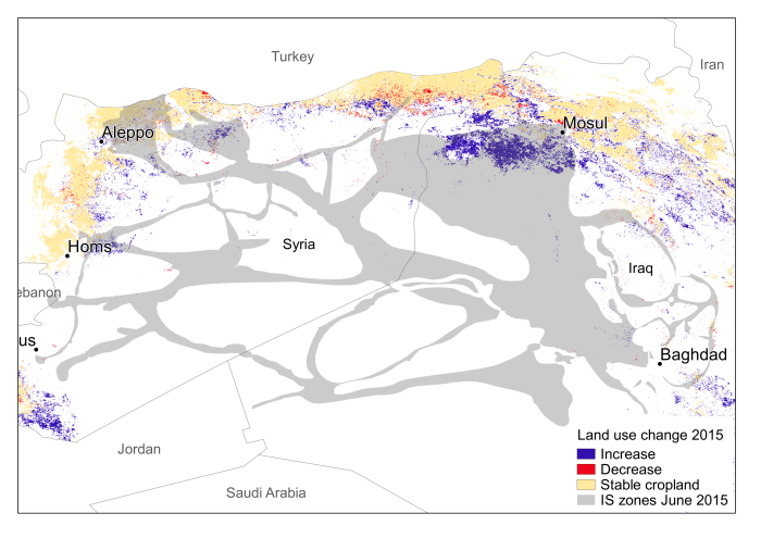
Increases and decreases in cropland in 2015
However, what we found was that almost 5% of the IS area had seen a conversion from fallow land to cropland in 2015, and that the cropland area had generally increased. We did find areas that had been turned fallow in 2015, but they were not as widespread as the areas that had gone from fallow to cropland.
Another interesting result show that the cropland with two harvest periods had been reduced and in many cases turned to single cropped. Inside the IS zones 25% of the double cropped land had been changed to single cropped, but outside the IS zones the corresponding number was 52%. So it seems that farmers in Iraq and Syria are having problems maintaining high-intensity agriculture, but that farmers inside the IS zones are better able to maintain this type of agriculture.
How does armed conflict affect agriculture?
The paper shows that there is not one single effect of armed conflict on agriculture. Instead, conflict can affect agriculture and land use in a multitude of ways, all dependent on local contexts. We need to put more research effort into understanding those local contexts, to better understand what types of situations that lead to land abandonment and what types of situations lead to increases in agricultural activity.
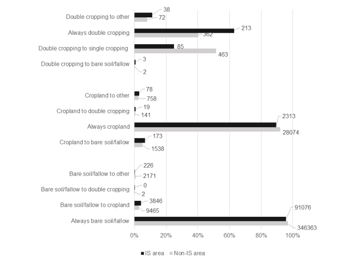
Changes in land use in 2015 in IS areas and non-IS areas (% and square km)
These results are to some extent contradicting local reports from farmers who have not been able to sow or harvest their lands since IS took control of areas. Our results show the changes in the whole area, while such news reports are representative for certain areas, but not all.
Does this mean that the food security situation had improved in 2015?
Probably not. We know that more land was used for agriculture, but that does not necessarily mean that more food was being produced. And even if that was the case, we wouldn’t know if that food is accessible to the people living there, or if it’s exported to bring in revenues to the IS. What we can say is that the reported food security issues are more likely due to problems of access and affordability, rather than problems of land inactivity.
Where can I learn more?
The paper is now published in the open access journal Environmental Research Letters where the whole paper can be accessed, along with a video abstract where me and Petter talk about our results. Below is the traditional abstract:
Socio-economic shocks, technogenic catastrophes, and armed conflicts often have drastic impacts on local and regional food security through disruption of agricultural production and food trade, reduced investments, and deterioration of land and infrastructure. Recently, more research has focused on the effects of armed conflict on land systems, but still little is known about the processes and outcomes of such events. Here we use the case of Syria and Iraq and the seizure of land by the Islamic State (IS) since 2014 as an example of armed conflict, where we investigate the effects on agricultural land use. We apply a reproducible approach using 250 m satellite-based time-series data to quantify the areas under cultivation from 2000 to 2015. Despite a common belief about widespread land abandonment in areas under conflict, results point to multiple trajectories regarding cropland cultivation in the IS seized area: (1) expansion of cropland to formerly un-cultivated areas, (2) cropland abandonment, and (3) decrease of high-intensity cropland. Our study highlights the need to understand these diverse conflict-related and context-dependent changes to the land system.
EKLUND, L., DEGERALD, M., BRANDT, M., PRISHCHEPOV, A. V. & PILESJÖ, P. 2017. How conflict affects land use: agricultural activity in areas seized by the Islamic State. Environmental Research Letters, 12, 054004.


Reblogged this on Sahel studies.
Hello, Sir could you please tell me about the methodology of single, double and multiple cropland classifications.
Hi Sadhan,
You can read that in the publication. Let me know if you have any specific questions.
Best,
Lina
Pingback: Mini-study: Conflict and nature in Iraqi Kurdistan | Population and Environment in the Middle East