Doing “remote field work” in Turkey

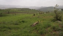
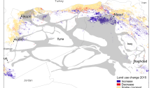
Here, we share a little bit more about the fieldwork process, and how we worked around the problem of not being able to go to the field during the first years of our project. A significant part of the Climate Stress Syria project consisted of data collection in Turkey, which we hoped would allow us…

Mini-study: Conflict and nature in Iraqi Kurdistan

On Tuesday this week it was the United Nations’ (UN) International Day for Preventing the Exploitation of the Environment in War and Armed Conflict (November 6th). Throughout the day, various organizations and people shared articles about how conflict affects the environment and how we need to prevent further exploitation of the environment due to conflict. Along with 58 civil society organisations and…

New publication: From Producers to Consumers: The Challenges and Opportunities of Agricultural Development in Iraqi Kurdistan

A paper that I’ve been working on since 2014 is finally done. Some papers take longer than others to mature, especially when they integrate different disciplinary perspectives. This paper is about agriculture in the Duhok governorate of Iraqi Kurdistan, the area i focused on in my PhD thesis. So in a way, this is an…

Guess which border!

I’ve downloaded a bunch of Landsat 8 data over the Middle East that I am planning to use to create training data for land use classification (like I did in this paper). Exploring satellite data is very useful for finding interesting research questions. In this False Color Composite from summer 2015 it’s quite evident that…

Cropland classification in Iraq: an investigation of MODIS LCP and scale issues

Just a few days after publishing my latest paper I came across a similar paper that had been published recently: “Sociopolitical influences on cropland area change in Iraq, 2001–2012” by Gibson, Campbell and Zipper. This article investigates changes in cropland area in Iraq and their connections to the sociopolitical situation in the country during this…

Corona Atlas of the Middle East

Yesterday I discovered the CORONA Atlas of the Middle East where you can look at old spy satellite images. The images below show Duhok city in 1967 and the same area, approximately 40 years later. Things have certainly changed. There was no Duhok dam in 1967 and Duhok city was not really a city.