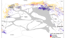
The problem with Climate Data in the Middle East

Climate data, including rainfall and temperature, are important for studying climate and water issues in an area. A major issue with doing research in the Middle East is getting access to reliable and complete data. In this blog I’ve talked about access to, and quality of, data, in posts like “Your guide to the “data…

Guess which border!

I’ve downloaded a bunch of Landsat 8 data over the Middle East that I am planning to use to create training data for land use classification (like I did in this paper). Exploring satellite data is very useful for finding interesting research questions. In this False Color Composite from summer 2015 it’s quite evident that…

Cropland classification in Iraq: an investigation of MODIS LCP and scale issues

Just a few days after publishing my latest paper I came across a similar paper that had been published recently: “Sociopolitical influences on cropland area change in Iraq, 2001–2012” by Gibson, Campbell and Zipper. This article investigates changes in cropland area in Iraq and their connections to the sociopolitical situation in the country during this…

Confusion Matrices Confuse me

I will admit that even though I’ve had a few courses on land use/cover classification and accuracy assessments during my Master and PhD, I always get confused about what user and producer accuracy are, and even more so what Kappa is. In trying to assess the accuracy of my phenology based classification of cropland, I…

Spurious Correlations

This joint post developed from several discussions about correlations with (soon to be) Dr Martin Brandt who helped write this post. You will find the same post on his blog, as well as many other interesting posts. Correlations are a very famous and popular way to express relationships (and their strength) between two variables. Applications in environmental sciences span from relations…